A new subdivision in the Boise Foothills was planned right below a steep drainage channel. After a wet spring, a small debris slide blocked the road. That is why we run debris flow analysis for developers before they break ground. We model the potential flow path, estimate the volume of mobilized material, and define the hazard zone using local topography and soil data. For slopes with loose colluvium, we combine this analysis with a stability assessment to check if the source area is likely to fail under heavy rain. Every project in Boise gets field verification and lab testing tailored to the site's geology.
Post-fire debris flows in the Boise Foothills can reach velocities of over 5 m/s on slopes steeper than 25 degrees.
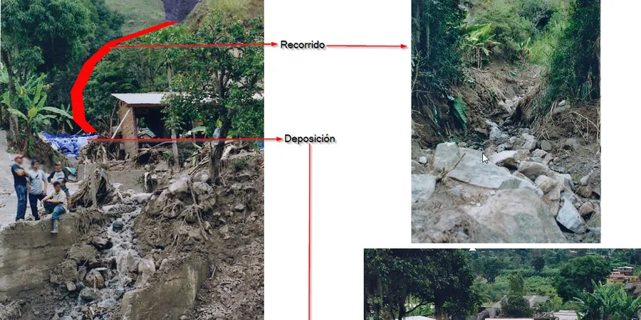
Methodology and scope
Local considerations
The most common mistake we see is ignoring the contribution of small tributary channels. Developers look at the main drainage and think the rest is safe. But in Boise, a 2-meter-deep gully can mobilize enough material to damage a house. Without a site-specific debris flow analysis, the design may lack adequate deflection walls or basin capacity. We have seen retaining walls overtopped because the flow volume was underestimated. Another error is assuming the soil has the same behavior after a wildfire. The ash layer reduces infiltration and increases runoff, which triggers flows at lower rainfall thresholds.
Applicable standards
ASTM D2487 (Unified Soil Classification System), USGS Open-File Report 2008-1176 (Debris-flow hazard assessment), FEMA Guidelines for Debris Flow Hazard Mapping
Associated technical services
Hazard Zoning & Runout Modeling
We map potential initiation zones, flow paths, and deposition areas using digital elevation models and site-specific soil parameters. The output is a hazard map with recommended building setbacks.
Soil Characterization Lab Testing
We perform gradation, Atterberg limits, and direct shear tests on samples from the source area and fan deposits. Results feed directly into the flow models and help classify debris mobility.
Post-Wildfire Risk Assessment
After a burn, we evaluate changes in soil infiltration, root cohesion loss, and runoff generation. This service is critical for developments that were previously considered low-risk.
Typical parameters
Frequently asked questions
What is the difference between a debris flow and a mudslide?
A debris flow contains a mix of coarse material (rocks, boulders, trees) and fine sediment, moving as a viscous slurry. A mudslide is dominated by fine-grained soil and moves more slowly. In the Boise Foothills, most events are debris flows because of the rocky colluvium.
How much does a debris flow analysis cost in Boise?
A standard debris flow analysis for a single drainage basin typically ranges between US$1.130 and US$4.420, depending on the basin size, the number of modeled scenarios, and the need for post-fire assessment. Contact us for a quote tailored to your site.
Does a debris flow analysis replace a slope stability study?
No. They address different mechanisms. Slope stability evaluates the factor of safety of a soil mass. Debris flow analysis focuses on runout, velocity, and deposition once a failure occurs. For a complete risk picture, we often run both.
How long does it take to get results?
Field work and lab testing usually take 2 to 3 weeks. Modeling and report writing add another 1 to 2 weeks. Total turnaround is typically 4 to 5 weeks for a standard residential subdivision.