ASCE 7 and the IBC set the framework for subsurface investigations in the US, but the local geology of Boise makes electrical resistivity survey particularly relevant. The city sits on a complex mix of alluvial deposits from the Boise River and fractured basalt flows from the nearby volcanic formations. A Vertical Electrical Sounding (VES) can differentiate these layers without drilling, providing a continuous resistivity profile. This method is often used early in a project to map the depth to bedrock or locate gravel lenses. For more detailed soil characterization, we combine VES data with ensayo SPT to correlate resistivity values with penetration resistance.
A VES survey in Boise can map the basalt-alluvium contact to within 1-2 meters, reducing drilling risk on the first attempt.
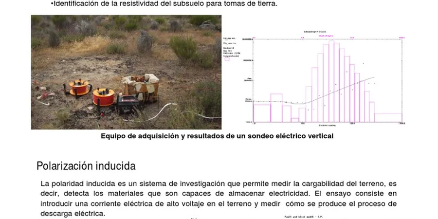
Methodology and scope
Local considerations
Boise expanded rapidly from farmland into the foothills and benchlands after the 1970s. Many subdivisions sit on old alluvial fans or basalt outcrops. Without a resistivity survey, a developer might assume uniform soil and hit unexpected bedrock or a high-water table. That can stall a project by weeks. We use VES to identify paleochannels and fractured basalt zones that could cause differential settlement. For sites near the Foothills, we recommend adding a masw-vs30 survey to measure shear-wave velocity for seismic site classification per ASCE 7.
Applicable standards
ASTM D6431-18 (Field DC Resistivity), ASTM D5777-18 (Guide for Surface Geophysical Methods), ASCE 7-22 (Minimum Design Loads, Seismic Site Class)
Associated technical services
2D Electrical Resistivity Imaging (ERI)
Multi-electrode system with 48 to 96 channels. Profiles up to 400 m. Output is a contoured resistivity section. Ideal for bedrock mapping, groundwater exploration, and landfill delineation. Includes inversion model with RMS error <5%.
Vertical Electrical Sounding (VES) – 1D
Schlumberger array with expanding electrode spacing. Four to six soundings per day. Used for depth-to-bedrock estimates and aquifer layer identification. Suitable for small lots or preliminary screening before detailed 2D work.
Typical parameters
Frequently asked questions
How deep can a VES survey reach in Boise's basalt terrain?
In areas with fractured basalt, a standard VES with 200 m spread reaches 40-60 m. The high resistivity of solid basalt can limit depth, so we sometimes switch to a dipole-dipole array for better penetration through resistive layers.
What is the typical cost range for an electrical resistivity survey in Boise?
For a standard 2D line with 48 electrodes and inversion, the cost ranges between US$580 and US$1,150. Shorter VES profiles are at the lower end. Final price depends on site access and number of profiles.
Can VES detect groundwater in the Boise River alluvium?
Yes. Saturated alluvium shows resistivity values below 50 ohm-m, while dry gravel is above 200 ohm-m. VES can map the water table interface and locate perched aquifers, which is useful for dewatering planning or well placement.
Do you need a permit for resistivity surveys in Boise city limits?
Generally no, because the method is non-invasive. However, if we deploy cables across sidewalks or streets, we coordinate with the Ada County Highway District. Private land access is your responsibility.
How long does it take to get results after fieldwork?
Data processing and inversion take 2-4 business days for a 2D line. A final report with interpreted lithology and resistivity sections is delivered within one week. Rush processing can be arranged for an additional fee.