In Boise, the transition from the Snake River Plain to the Rocky Mountain foothills creates a complex mix of alluvial fans, basalt flows, and lacustrine clays. We see it regularly: a developer buys land with a view in the Foothills, only to discover the cut slope is sitting on colluvial soils that ravel with every spring thaw. That is where slope stabilization design becomes the difference between a buildable lot and a perpetual maintenance problem. Before jumping to retaining walls, we often recommend a deep soil mixing program to treat weak layers in place, or at minimum a thorough subsurface exploration with SPT to map the profile. The goal is to match the stabilization method to the actual failure mechanism, which is rarely uniform across a site.
The transition from alluvial plains to mountain foothills means no two Boise slopes fail the same way, requiring tailored stabilization strategies.
Methodology and scope
Local considerations
Boise sits at an elevation of 2,730 feet, and the Foothills rise quickly to over 5,000 feet. That topographic gradient creates natural slope instability, and when you add seasonal snowmelt and occasional intense summer thunderstorms, the risk multiplies. The 2020 flood event in the Foothills triggered several shallow debris slides, reminding everyone that slope stabilization design cannot ignore surface water management. We have seen cut slopes fail years after construction because the drainage system was undersized. Proper design must account for the 100-year precipitation event and the soil's response to rapid saturation. Ignoring these factors leads to costly repairs, legal disputes, and unbuildable lots.
Explanatory video
Applicable standards
ASCE 7-22 (Minimum Design Loads for Buildings), IBC 2021 (International Building Code, Chapter 18), FHWA-NHI-05-088 (Geotechnical Circular No. 7 for Soil Nails), ASTM D1586-18 (Standard Test Method for SPT), ASTM D2487-17 (Standard Practice for Classification of Soils for Engineering Purposes)
Associated technical services
Geotechnical investigation for slopes
We conduct borings, test pits, and in-situ testing to characterize soil and rock layers. For Boise sites, we pay special attention to the colluvial mantle thickness and groundwater seepage zones. Laboratory testing includes direct shear and triaxial on undisturbed samples to obtain realistic strength parameters for the stability analysis.
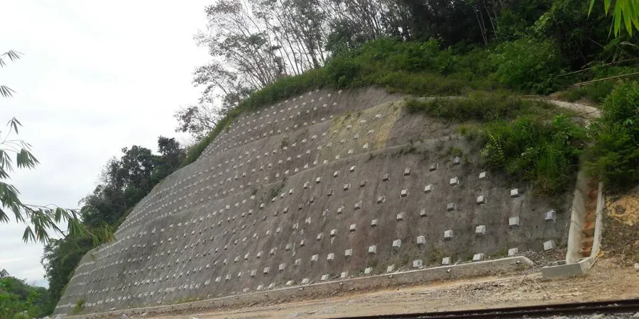
Stability analysis and remedial design
Using software like SLOPE/W or Slide, we perform limit equilibrium and finite element analyses. We then design stabilization measures such as soil nails, tieback anchors, drainage blankets, or geogrid-reinforced fills. For Boise's seismic environment, we also evaluate pseudo-static stability per ASCE 7 to ensure the slope can withstand a design earthquake.
Typical parameters
Frequently asked questions
What is the typical cost range for a slope stabilization design study in Boise?
For a standard residential or small commercial slope in the Boise area, the cost ranges between US$1,820 and US$6,230 depending on the number of borings, laboratory tests required, and the complexity of the stability analysis. Larger projects with multiple cross-sections and seismic considerations fall at the higher end.
How deep should borings be for a slope stability analysis in the Boise Foothills?
Borings should extend at least 10 feet below the deepest potential failure surface, or to a refusal layer such as competent basalt or dense claystone. In the Foothills, that often means drilling 20 to 40 feet deep to capture the colluvium and underlying weathered bedrock.
What laboratory tests are most critical for slope stabilization design?
Direct shear or triaxial tests on undisturbed samples provide the cohesion and friction angle values needed for limit equilibrium analysis. Atterberg limits and natural moisture content help assess the soil's sensitivity to wetting. For Boise clays, we also run consolidation tests to evaluate swelling potential.
How long does it take to complete a slope stabilization design project?
A typical project takes 4 to 6 weeks from field investigation to final report, assuming straightforward access and no delays in laboratory testing. Complex sites with multiple borings, seismic analysis, or regulatory review can extend to 8 or 10 weeks.