A field team mobilizes with portable drilling rigs and slope inclinometers to assess landslide hazards across Boise's steep terrain. The Boise Foothills, underlain by the Idaho Batholith granitic rocks and basalt flows from the Snake River Plain, create complex failure surfaces where clay-rich colluvium accumulates. Our landslide assessment begins with detailed geologic mapping and a walkover survey to identify tension cracks, disturbed vegetation, and scarps. We then install inclinometer casings to measure deep-seated movement over time. This data informs limit-equilibrium models using Bishop's method, calibrated against local failure history. The assessment follows ASTM D1586 for SPT sampling and ASTM D2487 for soil classification, ensuring compatibility with IBC and ASCE 7 loads. For larger projects, we integrate resistivity surveys to map subsurface stratigraphy without drilling every point.
Installing inclinometer casings in Boise's weathered granitic colluvium reveals movement rates as low as 2 mm per month — data that drives every mitigation decision.
Methodology and scope
Local considerations
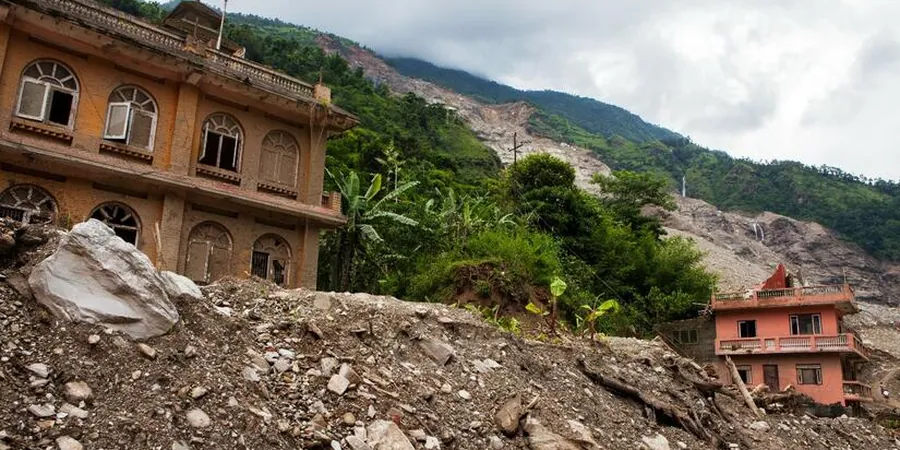
In Boise, many homeowners underestimate how shallow the failure plane can be — often less than 6 feet deep in colluvium over weathered bedrock. We frequently see tension cracks that were ignored until a wet spring triggered movement. Our landslide assessment identifies these early indicators before they become structural damage. We map drainage patterns because concentrated runoff from irrigation or roof downspouts saturates the soil and reduces effective stress. The most common failure mode here is a rotational slide in clay-rich layers, but we also encounter debris flows on steeper canyons after wildfire burns remove vegetation. Mitigation recommendations always include surface water diversion as a first step.
Applicable standards
ASTM D1586-18 (SPT), ASTM D2487-17 (Classification), FHWA-NHI-05-089 (Slope Stability), ASCE 7-22 (Minimum Design Loads), IBC 2021 Chapter 18
Associated technical services
Field Reconnaissance & Instrumentation
Includes walkover surveys, crack mapping, inclinometer installation, and piezometer placement to monitor pore pressures over multiple wet seasons.
Laboratory Testing & Soil Characterization
Direct shear, triaxial (CU), and Atterberg limits on undisturbed samples. We also measure hydraulic conductivity to model infiltration rates.
Slope Stability Analysis & Mitigation Design
Limit-equilibrium models using SLIDE or SLOPE/W. Outputs include factor of safety contours, recommended drainage systems, and retaining wall locations.
Typical parameters
Frequently asked questions
How much does a landslide assessment in Boise typically cost?
A standard residential assessment in Boise ranges from US$1.040 to US$3.640, depending on slope complexity, number of borings, and laboratory tests required. Large commercial developments may exceed this range.
What triggers landslides in the Boise Foothills?
Most failures occur after rapid snowmelt or intense spring rain, when water infiltrates colluvial soils over the low-permeability Idaho Batholith. Irrigation from landscaping also raises pore pressures. Wildfires reduce root cohesion, making burned slopes especially vulnerable to debris flows.
Do I need a landslide assessment for a new home in the Foothills?
Yes — Ada County requires a geotechnical report for any development on slopes steeper than 15 percent. Our assessment meets county review criteria and provides recommendations for foundation setback, drainage, and retaining walls.